
The Saltwater Magazine for Gulf Coast Fishing!

![]()

Magellan GPS - New Products
New GPS Magellan® Products Increase Safety
and Fun on U.S. Trails
Weston, WI., November 29, 2007- U.S. Trailmaps, Inc., the North American leading provider of digital outdoor recreational trail data will offer equestrian and snowmobile enthusiasts a new navigational tool available beginning this Fall, to help them explore thousands of miles of trails across the nation.
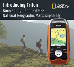
U.S. Trailmaps, a licensed Magellan Solutions Developer Kit (MSDK) developer for Magellan, has developed recreational trail maps for use with Magellan's leading series of GPS navigation devices, the Magellan Triton, eXplorist and CrossoverGPS. MSDK is Magellan's third party developer program that allows external developers to create custom content products and software for Magellan's consumer GPS products. The products will be marketed under U.S. Trailmaps' TrailPlan® brand and will include state-based recreational trails for equestrian and snowmobile activities.
   |
The TrailPlan products include rich features such as:
Ø Full interactivity with select Magellan GPS receivers
Ø Searchable trails, land areas, and POI's
Ø Trail related businesses
Ø Detailed roads
Ø Hydrography
"This venture represents the first time that inclusive recreational trail systems have been available in detail for GPS navigation systems. Our goal is to provide trail users with up-to-date, relevant and accurate information so that they can safely enjoy the outdoors," said U.S. Trailmaps vice president Mark Voss. "Being able to identify rest stops, food service, and medical care stations takes much of the apprehension out of exploring a new trail."
"The release of these new TrailPlan products for Magellan devices marks another step in our plans to supply consumers with the most accurate and robust map and content products for their GPS needs," said Justin Doucette, senior manager, product marketing for Magellan. "This is the first time that activity-specific trail maps have been released for a major recreational GPS manufacturer."
TrailPlan maps for Magellan Triton, eXplorist, and CrossoverGPS will be available the Fourth Quarter of 2007 at www.trailplan.com and www.magellangps.com for $29.99 per state.
About U.S. Trailmaps
U.S. Trailmaps' mission is, "to map all off-road trails in the United States and Canada." It is the North American leader in digital outdoor recreational trail data for use in location-based navigation systems and the creation of custom GIS recreational trail data. The privately-held company is headquartered in Weston, WI, and was launched in 2006 with funding from the Kegonsa Seed Fund I, managed by Kegonsa Capital Partners of Fitchburg, WI Kegonsa is Wisconsin's premier seed venture fund and the only Wisconsin fund named to Entrepreneur magazine's Top 100 VC Fund list this year.
About Magellan
Magellan is a leader in the outdoor, vehicle navigation, survey, GIS and OEM GPS navigation and positioning markets. Recognized as an industry innovator, the company is the creator of the award-winning Magellan RoadMate® series portable car navigation systems, Maestro, CrossoverGPS, the Magellan Triton outdoor handheld navigation devices, the Hertz® NeverLost® car navigation system and ProMark, the best-selling single frequency GPS survey product line on the market. Magellan is privately held and headquartered in Santa Clara, Calif., with European headquarters in Carquefou, France. For more information on Magellan, visit http://www.magellangps.com.