
The Saltwater Magazine for Gulf Coast Fishing!
FISHING FORECASTS
| FISHING CALENDARS | ARTICLES | ADVERTISE
| SUBSCRIBE
Search Gulf Coast Fisherman's
Web Site
Past articles, specific
places or fish, etc.

MOSES LAKE
Gateway to Protected Waters
by Capt. Nate Skinner
![]()
![]()
| CURRENT
MOON lunar phases |
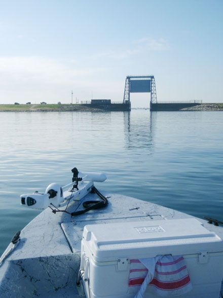
I asked the guide, What's that?" ,as the he untilidled our boat under a large, metal structure lined with concrete walls on either side. This created a sort of hallway or passageway as my then, ten year old eyes would see it, funneling the tide into a much smaller bay. "That's the floodgate leading into the lake," replied the captain, nonchalantly. We were drenched to the bone after a rough ride through open water, but the calm waters of this "new lake," looked invitingly "fishy." By the end of the day, our arms were sore from catching more redfish than we could shake a stick at!
To this day, I cannot remember the name of the captain my Dad and I were fishing with, nor what kind of boat we were in or what we used for bait. But, I will never forget the awe of passing under that gate. Even as a ten year old kid, it looked to me like a giant guillotine, ready to drop on the next boat to idle under it, as if it were guarding some secret angling Mecca, wall to wall with hungry game fish. That was the beginning of a lifetime's worth of fishing memories for me and my family, on a lake that offers opportunities to boaters, as well as waders, bank fishermen, and kayakers. It's action you don't to want to miss out on, and it's all happening on Moses Lake.
History
Located on the western end of Galveston Bay in northern Galveston County, Moses Lake stretches two miles wide and four miles long. Its waters come and go with the tides through a small opening into Galveston Bay, located at Miller Point. The cove on the eastern side of the lake is called Dollar Bay, named after the community of Dollar Point. The lake is also fed by Moses Bayou on its western side. This small stream runs through relatively flat and rich prairie country that nineteenth century geographers described as having large amounts of deer, along with buffalo and waterfowl. Highway 146 now runs along this western edge of Moses Lake, with a bridge crossing over Moses Bayou. Much of this land is still undeveloped with the exception of Texas City's Bayou Golf Course, in which Moses Bayou now winds itself through.
According to the Texas State Historical Association (TSHA), Moses Lake may have been named after Moses Austin, by his daughter, Emily M. Perry, who laid out the town of Austinia on Dollar Point Peninsula in 1839. On January 20, 1954, Texas City annexed the lake, by constructing a levy around the city, stretching from the northern shoreline, on around to the eastern edge of Moses, to protect against hurricane tidal surge from Galveston Bay. In 1966, the Army Corps of Engineers built a tidal control gate twenty two feet above sea level at Miller Point. The mean low-tide lake level was between one and three feet, but during heavy storms, the lake would crest to five feet. To prevent flooding from an increase in lake level, Texas City constructed an eight foot levy on the south end of Moses Lake, with ponding areas and Archimedes screw pumps. These pumps control the lake level, and lift storm waters from the city, over levees into the lake. The idea behind this is pretty simple. The city will drop or close the flood gate during peak low tide, before a potentially flooding storm is forecasted to make landfall in the area. This stops strong incoming tides being surged by the storm from entering the lake, giving the city a dumping a grounds for flood water, as they use the screw pumps to pull water from ditches into Moses Lake, preventing ditches from overflowing and keeping streets clear of floodwater.
In 1974, an eleven foot deep channel was dredged from Moses Bayou to Miller Point in order to accommodate shrimp boats harboring there. This channel has been extended towards the southern end of the lake, where residential development in Texas City has boomed. There are now neighborhoods with canals connecting to this channel, offering homeowners water front property, and direct access to the lake from their back yard. One of these canals contains a harbor, full of both commercial shrimp and oyster boats that dock there year round. This commercial fleet uses Moses Lake as a safe refuge from open bay waters, with convenient access to Galveston Bay via the channel that runs north and south through the floodgate on the lake's north end. On the southernmost part of this canal, lies The Fish Spot, a restaurant and bait camp that has a boat ramp offering direct access into Moses Lake. This gives boaters an opportunity to completely forgo rough, open bay waters by launching directly into the lake. This is also the only location to get a boat into the lake when the floodgate is down.
Angling Opportunities
Moses Lake is lined with mostly marsh grasses and is composed of a mud bottom with tons of scattered shell and small shell reefs, making it a haven for trout, redfish, and flounder. Because it is a small body of water, the lake is a great place to find fish, sheltered from the gusty winds of spring. Moses Lake has protected shorelines on all sides, offering areas to fish out of the wind, no matter its direction.
Although it is primarily considered a shallow lake, there are a couple of deep holes within the lake that will hold fish during the earlier, cooler parts of spring. In the northwest corner of the lake, lies "the deep hole," which is easily seen on most charts of Upper Galveston Bay, reaching depths of nearly forty feet. The edges of this hole are surrounded by shell reefs. During the colder parts of spring, fish will feed along the scattered shell ledges, using the deep water as shelter from the cold water temperatures. Free lining shrimp and bumping them along the ledges of "the deep hole" can be very effective. During and right after spring cold fronts, anchoring in the middle of the hole and fishing vertically by keeping your bait close to the bottom can work well too. Drifting the shell reefs along the edge of this hole is an option as well, and soft plastics rigged on a quarter ounce jig head will help you thoroughly work these shell edges.
Another deep water area is the northernmost section of the channel, right before you get to the floodgate. This location often experiences strong current, as it is near the floodgate, so using a larger weight to keep your bait down near the bottom is a must. Working the ledges of this channel with live bait or soft plastics is a killer way to catch flounder. This area is also a popular night time fishing spot. Setting up lights powered by a generator and dragging baits through the moving current can yield large numbers of trout and redfish during the warmer months of spring.
The shorelines of Moses Lake are often full of darting mullet and baitfish in the spring. Trout, redfish, and flounder can all be taken along these shorelines, and just about any method will work. An effective way to work the lake's shorelines is by using a popping cork rig. The lake waters are often off color, and this combined with the strong winds of spring can make your bait hard for the fish to find. Using a popping cork will help attract the fish to your bait by the noise it makes, and will also give you added weight to your line, allowing you to cast further in the wind. Using a cork with a rattle works best, and the windier it is and dirtier the water is, the more often you will need to "pop" the cork in order to draw a strike. Using live shrimp or a soft plastic such as a Gulp! Shrimp will work great, just make sure the leader under your cork is long enough to keep your bait close to the bottom when it is sitting still.
Accessing the Lake by Car
Moses Lake is also easily accessible by car for kayakers, wade, and bank fisherman. There are two ways to access the lake by motor vehicle-one location is on the north end of Moses Lake, and the other on the south end. The north end location is more geared towards bank fishermen desiring to fish the deeper waters around the floodgate. This can be done, by driving to the flood gate along Skyline Drive, the paved road on top of the levy around Texas City. Once you reach the floodgate, you can walk down the levy on either side and fish both the bay side and lake side. These areas can also be waded, but extreme caution must be observed. This water is adjacent to the deep channel that runs under the floodgate, and the current here is often moving swiftly.
The south end of Moses Lake is more inviting for wade and kayak fishermen,
offering muddy flats with scattered shell and marshy shorelines. This area
can be accessed by turning north off of Loop 197 (25th Avenue) onto 29th
street in Texas City. Once on the 29th street, just keep driving until
you see the lake on your left. It is legal to park on the side of the road,
and as long as you are in the water, you are not trespassing on any land
surrounding the lake. It is easy to walk into the marsh from 29th street,
and a kayak can be simply drug into the water from here as well.